10.2
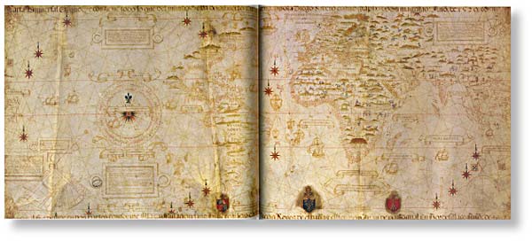
The Portugese cartographer Diego Ribero's map of the world (1529), showing Pope Alexander VI's 'line of demarcation', dividing the undiscovered world between Spain and Portugal, following the Treaty of Tordesillas in 1494. Despite the fact that no one had either the instruments or the techniques to locate or define the line with any accuracy, the mere fact of having a map enabled a division of the world with immense political ramifications. The division was renegotiated in the Treaty of Saragossa In 1529. Portugal paid Spain 350 000 ducats to move the line in the Pacific further east in order to protect its monopoly of the Spice Islands. This readjustment gave the Portugese all of Australia bar a thin slice of the east coast, though this was not recognised in the treaty since Spain did not know of Australia's existence and Portugal kept her knowledge secret. The original demarcation line was established at the longitude that separates Western Australia from South Australia to this day. The Atlantic demarcation line is indicated by the two small flags at bottom centre and the Pacific demarcation nag are below the Spice Islands in the open sea where Australia was not known to exist at this time, at least by the Spanish.

10.4
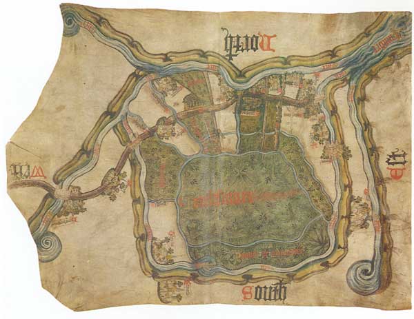
Map of Inclesmoor Yorkshire produced in a dispute during 1405-08 over rights to pasture and peal.

10.3
Augustus Caesar's edict on the 13th century Hereford mappamundi ordering a survey of the whole world.
While Australian Aborigines are capable of mobilising their networks beyond the local circumstance, this mobility does have social and technical limitations. But interestingly, it is because of the common social element in networks of power that Aborigines are able to use maps of their country, as shown by the dreaming tracks, in supporting land claims in white courts of law (ITEM 10.5). Thus in certain circumstances maps can be mobilised to move from one network or form of life and inserted in another. It is a mobilisation not always guaranteed of success as shown by such aboriginal examples as Hawk Puma (ITEM 2.6), the Chippewa Indians (ITEM 4.1), Non Chi Ning Ga (ITEM 4.6) and the Mexican Indians (see back cover). Examination of this issue is beyond the limits of this book, but the way knowledge in maps relates to social and political power is an important area for further study.
10.5
Story of the Yalata map by Kingsley Palmer, Australian Institute of Aboriginal Studies, Canberra.
The Southern Pitjantjatjara and the map of their Dreaming track
In 1981 as part of my research in the southern portion of the Great Victoria Desert I collected extensive information about the myths and tracks of the ancestral beings of the creative era of the Dreaming in this part of Australia. When my research was completed I drew up the Dreaming tracks and transferred this information onto a topographical map which provided a visual representation of the travels of the ancestral beings across this portion of Australia.
I subsequently returned to the community and took with me the map as a gift since I thought it was one way of demonstrating to the people something of the work that I had undertaken on their behalf. The response of the Aboriginal people was most interesting.
My Aboriginal helpers immediately regarded the map as an item of great cultural importance. They were concerned about the safety of the map and about the information that it contained. They considered that some of the details were in fact secret and should only be known by them. This was because a number of the myths included incidents that would generally only be discussed by mature and fully initiated men. They also recognized that the map contained secrets about their country and they were concerned to ensure that it did not fall into the wrong hands. They were particularly concerned about exploration geologists or certain government officers seeing the map and thereby understanding their secrets. It was agreed that the map would be placed in the vault of the bank in the nearby town. It was also arranged that the map could only be withdrawn with the permission of three of the older members of the community.
At this time the community was involved in extensive and protracted negotiation concerning the return of the Maralinga lands to the community. As a part of the negotiations a group of parliamentarians flew up from Adelaide to hold a meeting with the community at a site not far from the lands, in order to hear the Aboriginal claims to the country.
I was also invited to attend this meeting which was held in the sand dunes a few kilometres north of the trans-Australian railway line at a place known as Ooldea. When I arrived and the meeting commenced, I was surprised to discover that my map had been withdrawn from the bank. At a suitable time when the men had taken the parliamentarians to one side, the map was unrolled on the desert sands and the visitors were shown the Dreaming tracks as they extended over the countryside. The Aboriginal people were at great pains to point out the extent of the Dreaming tracks and the numerous sacred sites that were noted on the map and which were linked by the lines that represented the travels of the Dreaming ancestors.
Subsequently, in 1984, the majority of the Maralinga lands were handed back to the Aboriginal people who now hold this country freehold. The map has been returned to the bank where it has acquired the status of a title deed to the country. From the Aboriginal perspective it represents one proof of their close and enduring spiritual ties with their country. According to their understandings, the travels of the mythological beings and the sites they made are a spiritual reality which links them to the land and demonstrates their unity with it.