Just as maps can provide us with new knowledge by ordering it spatially, so do they provide ways of ordering and knowing our physical environment-the territory. Consider again a passage from Exhibit 1:
As we experience space, and construct representations of it, we know that it will be continuous. Everything is somewhere, and no matter what other characteristics objects do not share, they always share relative location, that is, spatiality; hence the desirability of equating knowledge with space, an intellectual space. This assures an organization and a basis for predictability, which are shared by absolutely everyone. This proposition appears to be so fundamental that apparently it is simply adopted a priori.
A. H. Robinson & B. B. Petchenik, The nature of maps: essays towards understanding maps and mapping, 1976, p.4

9.1
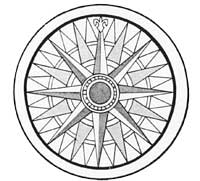
Compass rose
An essential way to look at what is implied in concepts like Robinson and Petchenik's 'spatiality' or Lewis's 'connectivity' is to explore their relationship to doing things in the material world – to consider how it is that we navigate or find our way about.
It might be thought that the ultimate evidence of the superiority of Western maps is their use in navigating on unknown waters or in unknown territory. If they are informed by a theory of projective geometry that takes account of the transformations involved in presenting a three-dimensional surface on a two-dimensional one, if they use a highly systematic representational mode, if they are drawn with great accuracy, then one can find one's way across otherwise featureless or foreign terrain. Conventional wisdom has it that 'primitives' do not have maps in the proper sense since they are familiar with the territory that they invariably traverse with great skill. It is sometimes said that such maps as they may have are just ritual objects, aides-memoire, messages of some sort or records of past events. Such views take no account of how we actually navigate today, how we navigated before modern maps were invented or how so-called 'primitive' maps are read or used.
The compass rose (ITEM 9.1), which appears on so many maps, is now often seen as a mere decorative space filler, a hangover from the days when maps were more like illuminated manuscripts than communication devices. In fact, the compass rose 'is a very abstract model, a cognitive schema, of the relations of direction to time, of solar time to lunar time, and of time to tide. [To use a Micronesian term,] it is an etak of medieval navigation' (p.266). It enabled medieval sailors to navigate successfully without literacy, writing, sophisticated instruments, the scientific method or Western schooling. They managed to negotiate the coastal waters of Europe and eventually Africa and the rest of the world without having either a map or foreknowledge. They achieved this by having a thorough understanding of the cognitive schema (C. O. Frake, 'Cognitive maps of time and tide among medieval seafarers', 1985, pp. 254-70).
To predict the tides requires a theory of the tides, a method of determining, recording and correlating solar and lunar time, and a memory of the lunar tidal schedule (the establishment of the port) for every locality. Piaget himself could not have designed a better task for testing formal operational thinking. The medieval sailor met this test ingeniously by appropriating a cognitive schema for spatial orientation – the compass rose – as an abstract device for recording and calculating time and tide.
He who wishes to learn to calculate the tides must first know all the points of the compass with its quarter points and half points, since this is the essential foundation of this matter and without it there can be no certainty.
Portuguese sailing directions, c. AD 1500
(Charles O. Frake, 'Cognitive maps of time and tide among medieval seafarers', 1985, p.262)
In order to find our way successfully, it is not enough just to have a map. We need a cognitive schema, as well as practical mastery of way-finding, to be able to generate an indexical image of the territory. ITEM 9.2 is a map of Juan Fernandos Island. To identify the island, you have to generate an image of what the island looks like from your position, as in the landfall sketch at the top. Thus indexical images are required in addition to the supposedly non-indexical information on the map (A. Gell, 'How to read a map: remarks on the practical logic of navigation', 1985, pp. 271-86). Though having a map makes the task of navigation a lot easier, it is not essential if you have a cognitive schema and practical mastery.
If we recall the Aboriginal bark paintings in Exhibit 5, we find it extremely difficult to see any topographical representation in them. The key map characteristic of spatiality or connectivity seems absent or sacrificed to the interests of symmetry or aesthetics. Reading them requires the acquisition of a large body of esoteric knowledge. However, David Lewis's example of the explanation given of a map of a journey he took with some Australian Aborigines shows that relative spatial location is indeed preserved. (Read ITEM 9.3.) It is accomplished through the telling of a myth that 'connects' the salient features of the landscape in the way the travellers experienced them. In other words, the bark painting can be read as a map only if you have a thorough understanding of the forms of life of Aboriginal culture. Likewise, European maps are not autonomous. They can only be read through the myths that Europeans tell about their relationship to the land.