4.1 (above)
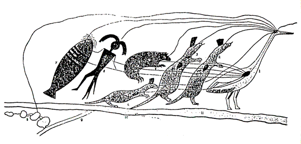
Chippewa Indian land claim presented to the US Congress In 1849.
This is the leading inscription, and symbolizes the petition to the President. No. 1. It commences with the totem of the chief, called Oshcabawis, who headed the party, who is seen to be of the Ad-ji-jauk, or Crane clan. To the eye of the bird standing for this chief, the eyes of each of the other totemic animals are directed as denoted by lines, to symbolize union of views. The heart of each animal is also connected by lines with the heart of the Crane chief, to denote u*nity of feeling and purpose. If these symbols are successful, they denote that the whole forty-four persons both see and feel alike – THAT THEY ARE ONE. No. 2, is a warrior, called Wai-mit-tig-oazh, of the totem of the Marten. The name signifies literally, He of the wooden Vessel, which is the common designation of a Frenchman, and is supposed to have reference to the first appearance of a ship in the waters of the St. Lawrence. No. 3. O-ge-ma-gee-zhig, is also a warrior of the Marten clan. The name means literally, Sky-Chief. No. 4, represents a third warrior of the Marten clan. The name of Muk-o-mis-ud-ains, is a species of small land tortoise. No.5. O-mush-kose, or the little Elk, of the Bear totem. No. 6, Penai-see, or the Little Bird of the totem of the Ne-ban-a-baig, or Manfish. This clan represents a myth of the Chippewas, who believe In the existence of a class of animals in the Upper Lakes, called Ne-ban-a-baig, partaking of the double natures of a man and a fish – a notion which, except as to the sex, has its analogies in the superstitions of the nations of western Europe, respecting a mermaid. No. 7. Na-wa-je-wun, or the Strong Stream, is a warrior of the O-was-se-wug, or Catfish totem. Beside the union of eye to eye, and heart to heart, above depicted, Osh-ca-ba-wis, as represented by his totem of the Crane, has a line drawn from his eye forward, to denote the course of his Journey, and another line drawn backward to the series of small rice lakes, No. 8, the grant of which constitutes the object of the Journey. The long parallel lines, No. 10, represent Lake Superior, and the small parallel lines, No. 9, a path leading from some central point on its southern shores to the Villages and interior lakes, No. 8, at which place the Indians propose, if this plan be sanctioned, to commence cultivation and the art of civilized life. The entire object is thus symbolized in a manner which is very clear to the tribes, and to all who have studied the simple elements of this mode of communicating ideas. (H. R. Schoolcraft, Historical and statistical information respecting the history, condition and prospects of the Indian tribes of the United States,* part 1, 1851, pp. 416-17)
The maps in this exhibit are from societies that were once called 'primitive', and as such they are supposed to stand in marked contrast with technically accurate maps of contemporary Western society. Malcolm Lewis, who has written extensively on American Indian maps, points out that they 'differed from post-Renaissance European maps in two fundamental respects: geometrical structure and the selection and ordering of information content'. European maps have a projective geometry based on a co-ordinate system. Indian maps are topologically structured 'conserving connectivity between the parts but distorting distance, angles and, hence, shape'. European maps have standardised representation, but Indian maps served specific functions in particular contexts (M. Lewis, 'Indian delimitations of primary biogeographic regions', 1987, p.94).