9.3
The way of the nomad
How do Aborigines find their way across the arid wastes of central Australia? Certainly, they achieve feats of unerring direction finding and tracking. To find out if their methods were in any way similar to the non-instrumental sea navigation of the Pacific Islanders, I travelled the fringes of the Simpson Desert in 1972 with the Antikarinya tracker Wintinna Mick . . . Then, in 1973 and 1974 the investigation was extended into the Western Desert under the tutelage of men, most of whom had spent their youth as nomadic stone age hunters. What I learnt from them was mainly through practical demonstration on the trail. The lifting above the horizon of a particular escarpment exactly at the point predicted; our arrival at a stated destination in accordance with intricate instruction after hard travelling; and our finding aimed-for waterholes – the ultimate physical necessity confirmed the value of their concepts and showed that I had grasped them correctly.

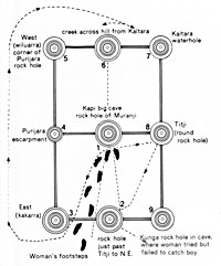
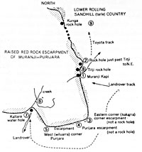
The diagram (top) shows how Big Peter Tjupurrula's picture represented Muranji Escarpment and Dreaming. Below is a sketch map of the same place – 'The map diagrams on Sydney suburban trains are quite as abstract as anything drawn by Aborigines'.

(David Lewis, 'The way of the nomad', in From earlier fleets: Hemisphere-an Aboriginal anthology, 1978, pp. 78-82)
The total distance I travelled with Aborigines in those three years was seven thousand eight hundred kilometres, including a thousand kilometres over completely trackless terrain. Most was by Land Rover, with a small proportion on foot. Several journeys required the laying of petrol depots. The longest was a round trip of sixteen hundred and sixty kilometres from Yayayi settlement, three hundred kilometres west of Alice Springs, to the abandoned wells on the old Canning Stock Route, eight hundred kilometres west of the last human habitation in the Northern Territory.
All my preconceived ideas about 'land navigation' turned out to be wrong. In place of the stars, sun, winds and waves that guide Pacific Island canoemen, the main references of the Aborigines proved to be the meandering tracks of the ancestral Dreamtime beings that form a network over the whole Western Desert.
The importance of sacred sites was brought out when I asked Aborigines to point out the direction of distant places. In thirty-three instances, accuracy varied between exactly right and 67 per cent error – an enormous scatter. But everyone of the big errors occurred when non-sacred places were being indicated. For the six far-away sacred sites the error was never more than 10 per cent and, in fact, averaged 2.80
The place was between Warren Creek and Ilpili, in western Loritja-Aranda country, familiar to Jeffrey Tjangala and Yapa Yapa Tjangala, both Pintupi. It was featureless and flat, with moderately open mulga and spear grass, devoid of sandhills, creek beds, escarpments, tall trees or other references. Visibility through the evenly-spaced mulga was a hundred metres at most.
A kangaroo, wounded by a bullet, was hunted on foot for half an hour. After it was killed, Jeffrey and Yapa Yapa headed without hesitation directly back towards the Land Rover that had been invisible since the first minutes of the chase.
Q. 'How do you know we are heading straight towards the Land Rover?'
A. Jeffrey taps his forehead. 'Malu (kangaroo) swing round this way, then this', indicating with sweeps of his arm: 'We take short cut.'
Q. 'Are you using the sun?'
A. 'No.'The Land Rover duly appeared ahead through the mulga in about a quarter of an hour. Jeffrey then repeated his explanation, illustrating by gestures and by drawing in the sand the malu's track and our own 'short cut' home.
Had Jeffrey any points of reference? The only external one was the starting point, and the sun was not consulted. He was not using the 'points of the compass' (which could have been found from the sun) nor, in this case, did sacred sites come into the picture. It would appear that Jeffrey was orienting on some kind of dynamic 'mental map', which was continually being up-dated in terms of time, distance and bearing, and more radically realigned at each major change of direction, so that the hunters remained at all times aware of the precise direction of their starting point.
Next day we drove on westward over country unfamiliar to both men. About a hundred and seventy kilometres on, and uncertain of our exact position, we camped in a mulga clump on gently undulating but remarkably featureless rira, or stony desert country. Jeffrey drew a cross in the sand to represent north, south, east and west: I confirmed by the stars that his directions were accurate. He said: 'North, south, east and west are like this in my head. I know them because we were travelling west and circled back south until we were heading south-east when we made camp.' He denied looking at the stars, and this was later dramatically confirmed by his inability to drive by the stars. Jeffrey went on to point out the directions of important Dreaming sites all around the horizon, beginning with one near Lake Disappointment, four hundred kilometres away.
In similar circumstances, Billy Stockman Tjapaltjari, and Anmatjara, explained that he always knew the directions while we were traversing a semicircular route 'by keeping them in my head when we turn another way.' All these explanation of orienting were, plainly, in terms of continually up-dated mental maps.
When an Aboriginal depicts a stretch of country he generally incorporates its mythical with its physical features, so stressing the inseparable interrelation between the two. Such paintings cannot be interpreted without inside knowledge, yet their emphasis on the spiritual attributes of places make them doubly memorable to the initiated. If such an abstraction seems strange, it is well to remember that Western maps, too, are often stylised. Neither contour lines nor the soundings on a chart are physical realities. Again, the map-diagrams on Sydney surburban trains are quite as abstract as anything drawn by Aborigines.
Let us now analyse a picture of Muranji Escarpment and Dreaming. This was painted in 1974 by Big Peter Tjupurrula, a Loritja and my kuta (elder brother), between our two visits to Muranji. It can be 'read' only by realising these three things: that the main Dreaming site is placed at the centre; the rock holes and other features are in the correct travel sequence and the corners of the escarpment (3 and 5) are approximately correctly oriented; the symbols representing rock holes and the rest have to be indentified by the 'map' maker himself.
The picture was taken with us on our second visit to Muranji to be explained and 'sung'. It is both the tory of the Dreamtime old woman who chases a little boy and also a 'map'. The 'singing' of this picture was a secret-sacred rite during which a white woman was sent out of earshot. It was also indispensable to the 'map's' interpretation.
Here is an example of faultless orientation by the most unobtrusive landmarks to physically or spiritually significant places (two waterholes and a flint knife deposit; two sacred places). The terrain was a spinifex-covered plain, with some low sandhills and a few undulations hardly deserving the name of hills; it was known personally or by repute to all the nine Pintupi in the party. Our objective, Tjulyumya, is a termination of the Wati Kutjura Tjukurpa, where a pattern of triangular yellow tones represent the Dreamtime papa (dingoes) that drove the two lizard men underground at this spot. It is extremely sacred and had not previously been known to white men. The Pintupi, whose present settlement is at Yayayi, had travelled four hundred and seventy-five kilometres westward into their old country to bring back to Yayayi some of the sacred yellow stones, and to gather mulyarri wood for spears.
The distance from our camp at Yunala to Tjulyurnya was forty-three kilometres, all cross-country. The courses were as follows:
1. Seven kilometres a little south of west to Namurunya Soak, a tiny hollow that seemed, to my eyes, to have no identifying marks at all.
2. Thirteen kilometres south-west to a site where kante, sharp flints used for stone knives, were found. This was beside a low rise in the ground.
3. Five kilometres south-east, then round the end of a sandhill to Rungkaratjunku, a sacred site.
4. Winding in and out between low sandhills, generally west-south-west, sixteen kilometres to Tjulyurnya rock hole by a little hill. The sacred place was two kilometres further on.The Pintupi's route-finding by these unremarkable landmarks was uncannily accurate. They alway knew just where they were, they knew the direction of spiritually important places for hundreds of kilometres around, and were oriented in compass terms.
Aborigines travelling on foot at night take pains not to impair their night vision and hence their ability to follow the terrain. According to Yapa Yapa Tjangala, it was invariably the practice in such circumstances to have the fire sticks carried at the rear of the column.
Aborigines who move out from their extensive home ground into less familiar country make use of a variety of guidelines. Detailed knowledge of the myth-reinforced geography of the Dreamtime tracks, with their 'camps' and sacred sites – all real places whose physical features are often mentioned in the songs and stories – greatly expands their terrestrial horizons, but only in rather general terms. Mythical information is rarely exact enough to enable a complete stranger to locate with confidence the waterholes upon which life depends.
Animated discussion of every conceivable aspect of places visited or known by repute makes up a good part of camp and wayside conversation. This is an important factor in extending a person's range – and it solves the water problem . . .
(David Lewis, 'The way of the nomad', in From earlier fleers: Hemisphere-an Aboriginal anthology, 1978, pp. 78-82)