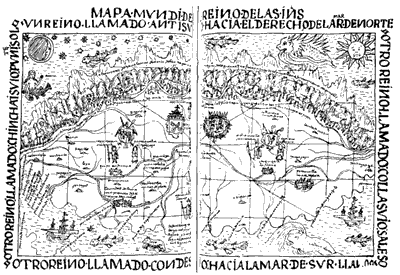
The significance of this rotation is much more interesting than a simple factual error. We now see that Hawk Puma's map follows long-standing Incan conventions after all. The explanation is historical. When the Inca expanded into Chile, a mountain pass had taken them by way of the great 'Eastern' society of the Collasuyu. Thus, Chile, to the south, came to be considered by the Inca as an eastern extension of their empire. Colombia, to the north, for similar reasons was considered a western extension. Furthermore, the map centres on Cuzco, the Inca capital, rather than on Lima, the Spanish capital; and its extent approximates the geographical limits of the Incan empire in South America, not the limits of the Spanish Indies, which the map purports to depict.

Sketch map of the west coast of South America showing the extent of the Inca empire before the arrival of the Spanish. Also shown are the approximate relations to Cuzco of the four neighbouring cultural groups which are identified on the four sides of Hawk Puma's map. Note that when rotated counterclockwise until the Condesuyu are south of Cuzco, this map approximates Hawk Puma's orientation.
Thus, the story of the Hawk Puma map teaches us that conventions often follow cultural, political and even ideological interests, but that if conventions are to function properly they must be so well accepted as to be almost invisible. The map, if it is to have authority in Western society, must have the appearance of 'artless-ness'; that is, it must appear simply to exhibit the landscape, rather than to describe it with artifice or in accordance with the perceived interests of the mapmaker. For a map to be useful, it must of course offer information about the real world, but if this 'real world information' is to be credible, it must be transmitted in a code that by Western standards appears neutral, objective and impersonal, unadorned by stylistic device and unmediated by the arbitrary interests of individuals or social groups. (We frequently use maps that are highly stylised though: for example, guide maps to places and institutions.) Hawk Puma's map was almost certainly never seen by the King of Spain, and his petition never read. It may be that this failure resulted at least in part from the visibility of the Incan conventions, which would have been read by the Spanish eye as inaccuracies, thus calling the map's credibility into doubt.

2.6
Hawk Puma's map
In this regard, maps prove once again an apt metaphor for scientific discourse. Scientific representations of the phenomenal world are, like maps, laden with conventions, which are kept as transparent, as inconspicuous, as possible. This has, in the past generation, been brought home to us through the work of many commentators. Scientists, such as Peter Medawar, have described how scientific papers systematically conceal actual scientific practice ('Is the scientific paper a fraud?', 1963). Philosophers and sociologists of science have pointed out that though we may grant that there is an external material world, we can gain no direct, unmediated experience of it. This obviously makes for a considerable difficulty. If there is a material world, and we have no direct experience of it, what is the relationship of our representations of the world to that world? Philosophers and sociologists who have taken a constructivist approach hold that rather than accept a split between the world and our experience of it, we should consider our representations of the world as active constructions. On this view, our experience of the world and our representations of it are mutually interdependent, so there is a sense in which the two are inseparable. Or, to put it in its most contentious form, 'the map is the territory' .