Interested as we are in landscape and its representation, wäŋa too is a useful concept for us to investigate. Orientation in space is of prime concern for Yolngu. Any recounting, whether ancestral, historical or contemporary, is framed by a discussion of place: where events happened. Events coalesce in space rather than in time; landscape punctuates stories, and behind this is the 'working assumption' that human activities 'create' places by socialising space.
Yolngu do not build a domesticated space and oppose it to 'wild nature' outside this domain, instead they are truly at home when they walk through the bush, full of confidence in knowing it as their own place. A camp can be made almost anywhere within a few minutes: a smooth place to sit or lie, a fire and perhaps a billycan of tea. Previously unmarked country becomes a camp, a wäŋa, with all the comforts of a familiar sitting room. The way of thinking which enables people to make a camp almost anywhere they happen to be, with no sense of dislocation, is a way of thinking that has the country as its own universe of meanings. Yolngu, who like to move and shift so regularly from specific place to specific place, have made space their own. Space is localised; landscape, a home, a wäŋa.
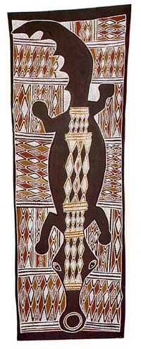
But wäŋa is more than this; it is in fact a very complex bundle of concepts. In calling up notions of socialised space it is used in connection with the temporary site at which people live, but it also means 'enduring country' – a named place. Wäŋa in this sense carries with it connections to all other named places. Wäŋa is not only the human creation of 'camp' but also the Dreaming creation of 'country', a concept primary to Yolngu social organisation. In the first dhulaŋ we shall consider (see ITEM 5.2), the salt water crocodile (bäru) is said to have its legs splayed out 'holding the wäŋa with his feet' (Gulumbu Yunupiŋu, 1987).
The interprelations of the dhulaŋ given here are the product of conversations between Helen Watson of Deakin University and the artist Djamika Munuŋgurr and his wife Guiumbu Yunupiŋu and daughters Ŋalawurr Munuŋgurr and Wuyuwa Munuŋgurr on April 1988. The discussions were held with the specific intention of generating the information in a form suitable for the publication.
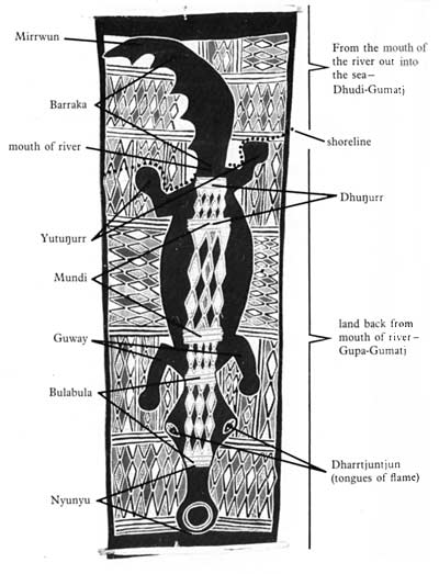
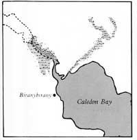
If the dhulaŋ in ITEM 5.2 is oriented with the crocodile's head pointing upwards, then it can be recognised as a map in the conventional Western sense. The place mapped here is called Ŋalarrwi, near Biranybirany (the homeland centre of the Gumatj people, which can be located on ITEM 5.1). The position of the crocodile's feet and body define the area of the Gumatj clan homeland by holding on to it. The coast is represented by the rear legs, the mouth of the river is where the tail joins the body.
By looking at the detailed Western map of Caledon Bay (ITEM 5.3) you can identify the section of river that is being referred to here. The land which is owned by the Gumatj clan extends in all directions from this river. Its boundaries are not shown here for to do so would be 'a breach of good custom' (Nancy M. Williams, The Yolngu and their land, 1986, p. 19).


5.2
Crocodile and fire dreaming; moiety – Yirritja; clan – Gumatj; painter – Djamika Munuŋgurr, 1985.
This dhulaŋ 'maps' the homeland of the Gumatj clan. The names of the parts of the crocodile are the names of areas of land. There are names for general areas like Gupa-Gumaq and Dhudi-Gumatj, which name separate sections of the clan. Also there are very specific names like Djarrqunqun, which names a small and restricted area.
The dhulaŋ represents a specific place where the crocodile (an Ancestral Being) lives, and the graphic elements are organised on spatial principles: that is, they are intended to correspond to elements of the landscape. Hence it is a map. However, it is obviously a highly conventional map. In order to able to read it, you have to know something of the stories, songs and dances of the creation of this landscape by this Ancestral Being and his kin.

5.3
Western map of Caledon Bay
The background pattern, or mittji, is 'the fire dreaming', a design owned specifically by the Gumatj. The irregularities of the 'diamond design' indicate flickering flames going in all directions. Here fire is a metaphor for knowledge:
Fire always has the same elements: flames (the red diamonds); ashes (yellow diamonds); sparks (white dots); charcoal (black lines); flaming coals (white with red lines); dust (white lines on yellow) but in any particular fire these elements combine and manifest in different ways. So it is with knowledge: the general elements and their relations are always there but the way knowledge is revealed anew to each generation is particular for that generation and that time. Gulumbu Yunupiŋu, 1987