Each part of the crocodile has a name and the 'outside names' – those that can be generally known – are shown in ITEM 5.2. The pattern we see on the back of this crocodile, and indeed all crocodiles, represents the murky water which is its wäŋa:
Dhulaŋ like this one are for teaching children – they learn from the bark and from the land itself. Children can learn the shape of the land from the bark, and from being instructed about what is written there. From being instructed they can get a map in their heads. Children can learn to have respect for the wäŋa in this way and the wäyin (game animals) that live there, and learn to mind it properly. If they don't do that it will take its revenge. Gulumbu Yunupiŋu, 1987
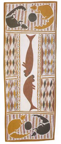
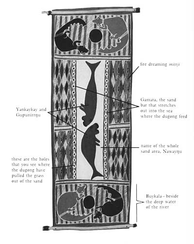
The bark shown in ITEM 5.4 is a large-scale portion of the one shown in ITEM 5.2: it is one side of the river. The name of the place represented here is Badaymirriwuy. If you stand at the mouth of the river facing the land, it is on the left-hand side. Beside this sandy stretch of river bank are the crocodiles' water holes. The name of that place is Buykala.


5.4
Dugong and fire dreaming; moiety – Yirritja; clan – Gumatj; painter – Djamika Munuŋgurr, 1985.
The central white area is the sand bank Ṉayawaŋu. It stretches out at the mouth of the river, the area of the crocodile's tail in ITEM 5.2. The dugong (two Ancestral Beings) feed on the sea grass on the edge of the sand bar Gamata. In doing so they leave the holes depicted around the white area.


5.5
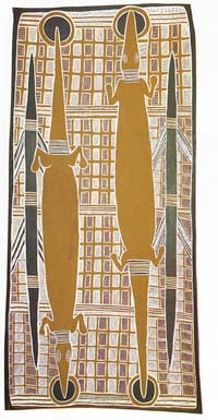
Water goannas and water dreaming; moiety – Dhuwa; clan – Djapu; painter – Djamika Munuŋgurr, 1985.
This dhulaŋ portrays the episode in which a Dhuwa place, Balana, was created and named by the Ancestors, the two Djan'kawu sisters. In this place, a green eat grove, the two sisters, the water goannas, made the water holes with their walking sticks. The name of the water holes is Mirrana. The sisters both enter and re-emerge from the ground here, shown by the fact that the holes are at both ends of the animals. The background patterning, the miṯtji, represents the ‘water dreaming', which is a metaphor for the way knowledge continues in its structure unchanged – it continually bubbles up in the same place. The pattern carries the idea that, while for each generation knowledge is revealed anew, the structure of the knowledge is always there, continually bubbling up.
The organisational principle employed in ITEM 5.5 is not spatial, it carries a narrative which is specifically located. Though it depicts topographical features we would hesitate to call it a map. As an account of what happened at one particular stopping place in the journey of the Ancestral Beings, it could be described as a diagram rather than as a map.
Pronunciation of Yolngu words
Balana - Ba-la-na
Badaymirriwuy - Bud-ae-mirri-woi
bäru - bar-roo
Biranybirany - Bir-ane-bir-ane
Buykala - Boi-kala
dhulaŋ - dthoo-lung
Dhuwa - Dthoo-wa
djalkiri - djal-kiri
Djan'kawu - Djan-ka-woo
Gamata - Ga-ma-ta
Gumatj - Goom-ach
Mirrana - Mirr-a-na
miṯjji - mint-jee
Ŋalarrwi - Ng-a-larr-wi
Ṉawayŋu - Na-wae-ngu
wäŋa - waa-ng-a
Waŋarr - Wa-ng-arr
wyin - waa-yin
Yirritja - Yirr-i-cha
Yolngu - Yol-ng-oo
Only after much deliberation can we decide whether to translate dhulaŋ as 'painting', 'map', 'diagram' or 'graphic representation'. In making this decision, it may be useful to seek out other bark paintings to study. For example, refer to ITEM 4.40 in Beasts and other illusions (p. 55) and ITEM 4.3 in Imagining landscapes (p. 51). What do you make of these dhulaŋ? Can a European attempt to recount some of the information encoded here? Does it help to know something of the theory behind the production of dhulaŋ? In Exhibit 4 in Imagining landscapes (ITEMS 4.4, 4.5, 4.7 and 4.15) we see maps produced by Aboriginal people with a different set of graphic conventions. One intuits that these mapmakers share something of the Yolngu 'theory of the land' from the explanations that are provided here.
In considering the ways in which dhulaŋ are maps, we must not lose sight of the fact that dhulaŋ are also religious icons. They have at least two aspects in common with Christian religious icons. Firstly, they present another, 'transcendental', world; they carry with them the presence of Waŋarr – the Time and the Beings of the Dreaming – in much the same way Christian icons present 'the living God'. The second element they have in common with Christian icons is that they are a 'gloss on text', the narrative of the Dreaming. Dhulaŋ are maps only insofar as the landscape is itself a 'text'. Unlike Western maps, dhulaŋ do not seek to represent the text of landscape 'in ratio'; they do not seek the 'rational representation of nature'. Dhulaŋ and Western maps have different theories of picturing because they are produced within different theories of knowledge. It is because the Yolngu knowledge system has landscape itself as a meaning system, through which meanings are made following the actions of the Ancestral Beings, that dhulaŋ are coincidentally maps and icons. Rights in graphic representation, in dhulaŋ and other ways of presenting the Ancestral World (song and dance) are inextricably interwoven. The Ancestral Beings handed over the land to particular human groups. The condition of maintaining the world in this proper state is that those groups continue to perform ceremonies and produce the paintings and ceremonial objects that commemorate their creative acts.
We might say that in a profound way the Ancestral Beings of the Yolngu were mapmakers. They created the landscape and at the same time made the country a map of itself in the knowledge network. They created the symbols and the ways of their use so that the map might be read by those to whom these things have been revealed. Reading the map is penetrating deeper into the texture of the knowledge network – the land itself.